Mary Kay Mason, Book Project Director, Laramie, Gem City of the Plains (Curtis Media Corporation, 1987)
T. A. Larson, History of Wyoming, (University of Nebraska Press, 1978)
Deborah Hardy, Wyoming University: The first 100 years 1886-1986 (Laramie, Wyoming: University of Wyoming, 1986)
Lola M. Homsher, The History of Albany County, Wyoming to 1880 (Lusk, Wyoming: Privately Published, 1965)
Charlie Peterson and the Laramie Plains Museum, Laramie: Images of America (Charleston, SC: Arcadia Publishing, 2007)
Faculty of University of Wyoming, In Memoriam; Grace Raymond Hebard, 1861-1936 (Laramie, Wyoming, University of Wyoming, June 1937)
Mike Mackey, Inventing History in the American West (Casper, Wyoming: Mountain States Lithographing, 2005)
Wyoming State Historical Society, accessed August 2014, www.wyshs.org
Wyoming State Archives, accessed February 2014 – October 2014, wyoarchives.state.wy.us
American Heritage Center (at the U. of Wyoming), accessed January 2014 – November 2014, www.uwyo.edu/ahc, www.uwyo.edu/ahc/digital
Wyoming Tales and Trails, accessed February 2014 – November 2014, www.wyomingtalesandtrails.com
Wyoming Territorial Prison Museum, accessed June 2014 – August 2014, http://wyoparks.state.wy.us
The Wyoming House for Historic Women, accessed July 2014 – September 2014, www.thelouisaswainfoundation.com/the_wyoming_house_for_historic_women
All posts by CavalrymanSteakhouse
Restaurant History Resources
Bob Gerard, Interview by Deborah Linden, In Person, Fort Collins, Colorado, April, 2014
Dick Van Pelt, Interview by Deborah Linden and Bella Pope, In Person, Laramie, Wyoming, June 2014
Ann Mullen Boelter, Interviews by Deborah Linden, In Person, Laramie, Wyoming, July 2014 – October 2014
Ann Mullen Boelter, Photo’s and information about the Hitchcock Family (Ann Mullen Boelter, accessed 2014)
Fort Sanders History Resources
Mary Kay Mason, Book Project Director, Laramie, Gem City of the Plains (Curtis Media Corporation, 1987)
Lola M. Homsher, The History of Albany County, Wyoming to 1880 (Lusk, Wyoming: Privately Published, 1965)
Ray Revere, The History of Fort Sanders Wyoming (Masters Thesis, University of Wyoming, 1960)
Candy Moulton, Forts, Fights and Frontier Sites (Glendo, Wyoming, High Plains Press, 2010)
Frances E. Strayer-Hanson, Medicine Bow Valley Pioneers: Closing the Overland Trail Opening the Union Pacific Railroad (Bloomington, Indiana, iUniverse Inc., 2009)
Jay Monaghan, The Overland Trail (Indianapolis, Indiana, Bobbs-Merrill, 1947)
T. A. Larson, History of Wyoming (University of Nebraska Press, 1978)
Wyoming State Historical Society, accessed August 2014, www.wyshs.org
Wyoming State Archives, accessed February 2014 – October 2014, wyoarchives.state.wy.us
American Heritage Center (at the U. of Wyoming) Accessed January 2014 – November 2014, www.uwyo.edu/ahc
Wyoming Tales and Trails, accessed February 2014 – November 2014 www.wyomingtalesandtrails.com
Annals of Wyoming, accessed June 2014 – October 2014, www.archive.org
The Boomerang Newspaper, accessed March 2014 – November 2014, http://www.laramieboomerang.com
Jerry Hanson, Interviews by Deborah Linden, In Person, Laramie, Wyoming, Laramie Plains Museum, January 2014 – October 2014
Phil Roberts, Interview by Deborah Linden, In Person, Laramie, Wyoming, April 2014
Kim Viner, Interviews by Deborah Linden, In Person, Laramie, Wyoming, April 2014, July 2014
Wyoming Newspaper Project newspapers.wyo.gov
F.K. Freeman, Frontier Index, (Laramie, Dakota Territory, Freeman and Company) April 2, 1868 – July 21, 1868
Frontier Index Editions – April 21 & 28, 1868
Frontier Index Editions – May 5, 19, 22, 26 &29, 1868
Frontier Index Editions – June 2, 5, 9, 12, 16, 19, 23, 26 & 30, 1868
Frontier Index Editions – July 3, 7 & 21, 1868
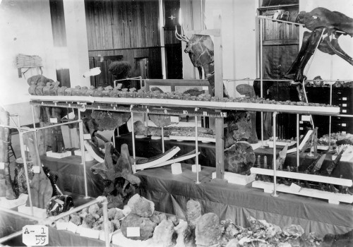
University of Wyoming Geological Museum

Dr. Wilbur Knight is one of the primary reasons that the University of Wyoming’s Geological Museum has long enjoyed its top-notch reputation. Knight served as the assistant territorial geologist of Wyoming from 1886-1887 and was appointed state geologist in 1898. He joined University of Wyoming’s faculty in 1893, and became the curator of the Geological Museum in addition to his instructional responsibilities.
Knight led many expeditions into the Wyoming heartland, famous for being one of the richest fossil regions in the United States. He was the leader of the 1899 Union Pacific Railroad Expedition in which railroad officials invited geologists and paleontologists from universities, colleges, and museums around the country to participate in a scientific expedition to Wyoming.
Although Wilbur Knight died rather young, his son Samuel “Doc” Knight, a legendary Wyoming geologist in his own right, later became the curator of the museum and expanded its scope. The Geological Museum at the University of Wyoming has since become a tremendous attraction in Laramie and an asset to Wyoming.
Learn more about Dr. Wilbur Knight and the University of Wyoming’s Geological Museum.
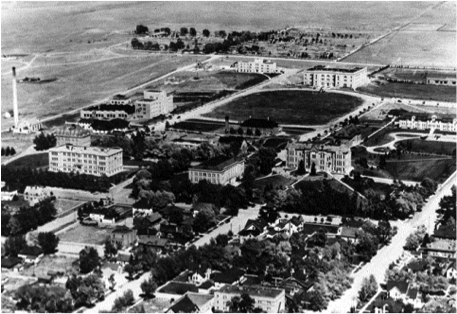
Aerial View of the University of Wyoming Campus
The aerial view of the University of Wyoming campus in this photograph shows how the city of Laramie was expanding to the east, bordering university property at 9th Street. The Green Hill Cemetery is at the top left of the picture. Corbett Field can be spotted at the top right, next to Half Acre gym. Old Main is pictured halfway down on the right side. Today, the University has grown to encompass all of this property.
During the Depression, government programs like the Works Progress Administration (WPA), the National Youth Administration (NYA) and the Civilization Conservation Corps (CCC) operated on campus and in the Laramie area. The following decades would bring many changes to the physical design of the campus.

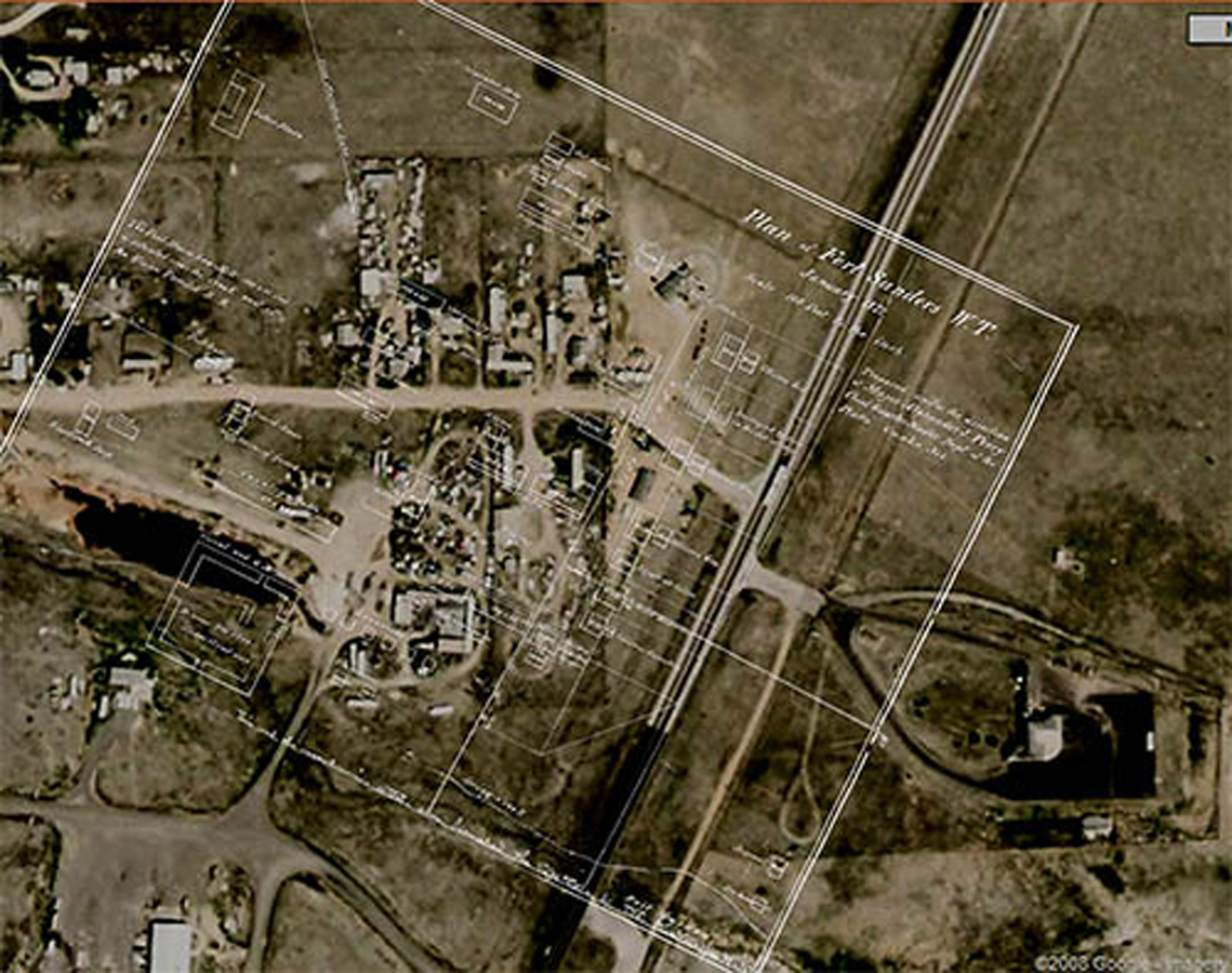
Fort Sanders Overlay
In 1862, Ben Holladay moved the route for his Overland Stage Line from the more northerly Oregon Trail route in the belief it would be safer from Native American attacks, as well as closer to Denver, by then booming from the Pikes Peak gold rush. Holladay named the route for his company and maintained stations along the line, which passed from Colorado into what’s now Albany County before heading west across Wyoming Territory. The present U.S. 287 highway follows the old stage route north from Colorado.
Holladay’s stations served travelers and agents at Virginia Dale, Colorado Territory, and in Wyoming Territory at Willow Springs, Big Laramie, Little Laramie, Cooper Creek and Rock Creek. Holladay outfitted his stations with hunters, blacksmiths and various other accommodations.
Native American attacks on travelers and stations increased in 1865. The U.S. Army decided to establish a post on the Big Laramie River as near to the Overland Stage route as possible. General John Pope charged Captain Mizner of the 18th U.S. Infantry with finding the best location for this fort. Fort Collins and Fort Halleck were being decommissioned at the time and their structures and stores were used in the creation of the new fort. In 1866, Mizner built the first permanent structure in the area. This was a wooden fort initially named Fort Buford in honor of General John Buford, a hero at Gettysburg and friend of General Pope. Since there was already a Fort Buford in Montana, confusion caused the name to be changed within months to Fort Sanders in honor of Brig. Gen. W.P. Sanders.
At one time 600 soldiers were housed at Fort Sanders, but numbers dropped due to fear of attacks. The military reservation covered 81 square acres of southeastern Wyoming in its heyday. The fort grounds were 223 feet (68 m) by 400 feet (122 m), including a parade ground. The post was originally built for four companies, but was later expanded to accommodate six. Nearly all of the buildings were constructed of wood except for the stone guardhouse, which was built in 1869 and remains the only structure standing today. Very little remains of the settlement which was decommissioned in 1882. The post Commander’s quarters were moved to LaBonte Park in Laramie and have been used as a community center and pre-school for decades.
The garrison at Fort Sanders frequently protected railroad crews from attack all along the rail line from the Laramie Range and across the plains. Initially, Fort Sanders was the county seat for the original Laramie County (as created by the Dakota Territory), which was almost all of what later became the Wyoming Territory. On Jan. 3, 1868, Dakota lawmakers moved the Laramie County seat to Cheyenne and created a new Carter County out of the western half.
Learn more about the history of Fort Sanders and the building of the Transcontinental Railroad.
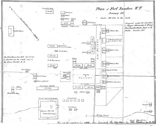
Fort Sanders Diagram
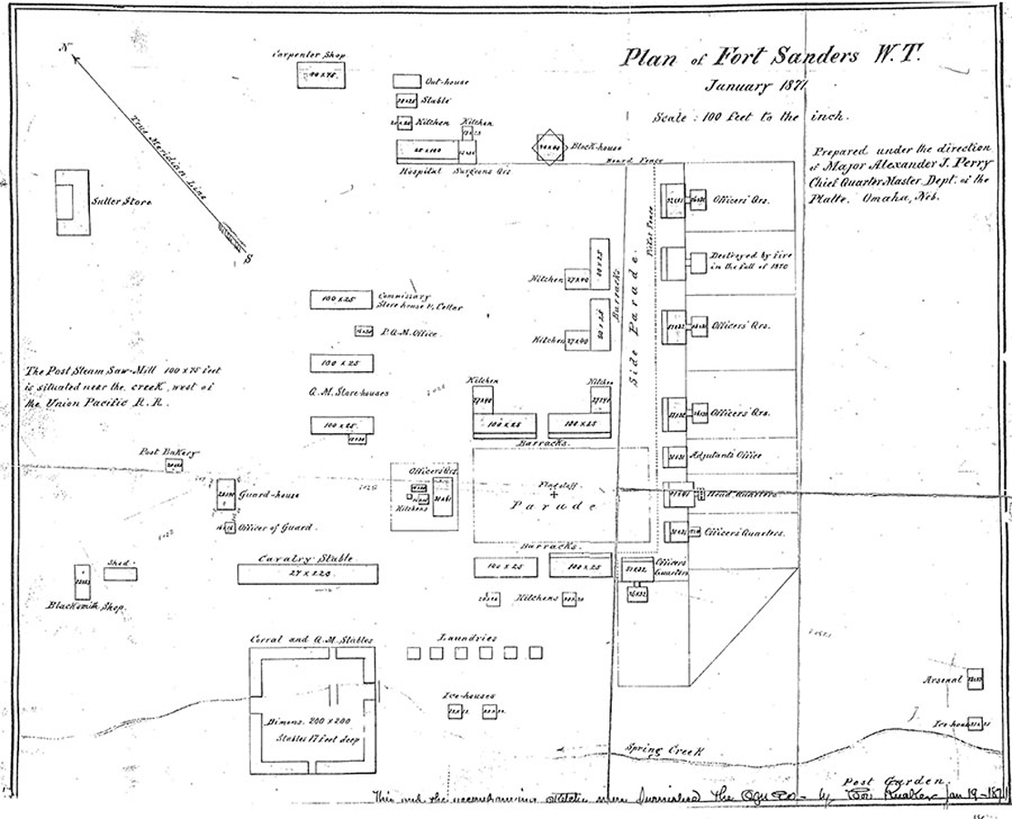
At one time 600 soldiers were housed at Fort Sanders, but numbers dropped due to fear of attacks. The military reservation covered 81 square acres of southeastern Wyoming in its heyday. The fort grounds were 223 feet (68 m) by 400 feet (122 m), including a parade ground. The post was originally built for four companies, but was later expanded to accommodate six. Nearly all of the buildings were constructed of wood except for the stone guardhouse, which was built in 1869 and remains the only structure standing today. Very little remains of the settlement which was decommissioned in 1882. The post Commander’s quarters were moved to LaBonte Park in Laramie and have been used as a community center and pre-school for decades.
The garrison at Fort Sanders frequently protected railroad crews from attack all along the rail line from the Laramie Range and across the plains. Initially, Fort Sanders was the county seat for the original Laramie County (as created by the Dakota Territory), which was almost all of what later became the Wyoming Territory. On Jan. 3, 1868, Dakota lawmakers moved the Laramie County seat to Cheyenne and created a new Carter County out of the western half.
Learn more about the history of Fort Sanders and the building of the Transcontinental Railroad.
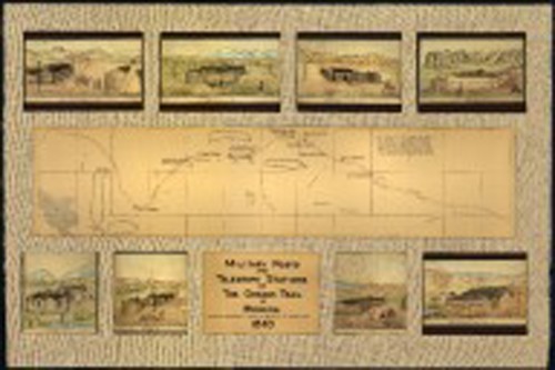
Military Posts and Telegraph Stations on the Oregon Trail in Wyoming, 1863

Map and pencil drawings of military posts and telegraph stations on the Oregon Trail in Wyoming.
From about 1811-1840, the Oregon Trail was laid down by traders and fur trappers. It could only be traveled by horseback or on foot. By the year 1836, the first of the migrant train of wagons was put together beginning in Independence, Missouri and traveled a cleared trail that reached to Fort Hall, Idaho.
Original drawings by U.S. Army 11th Ohio Cavalry soldier, Bugler C. Moellman.
Learn more about Fort Sanders and the building of the Transcontinental Railroad.

Laramie in 1870
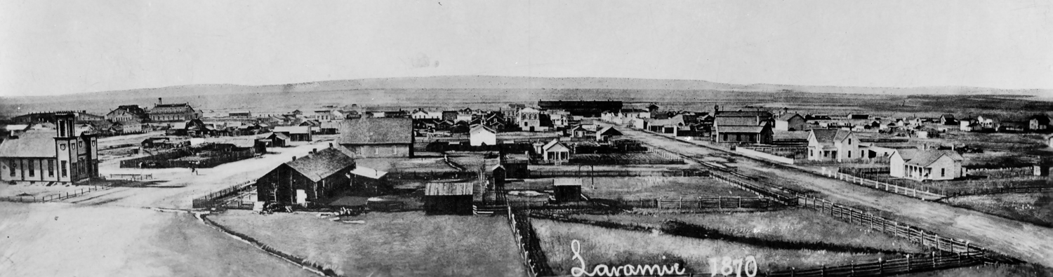
Here is a drawing of the newly created town of Laramie, Wyoming. Laramie grew very quickly — from a tent-end-of-tracks town (aka “Hell on Wheels”) to a permanent and thriving community boosted by the presence of the Union Pacific Railroad.
Learn more about Fort Sanders and the building of the Transcontinental Railroad.

Laramie in 1875
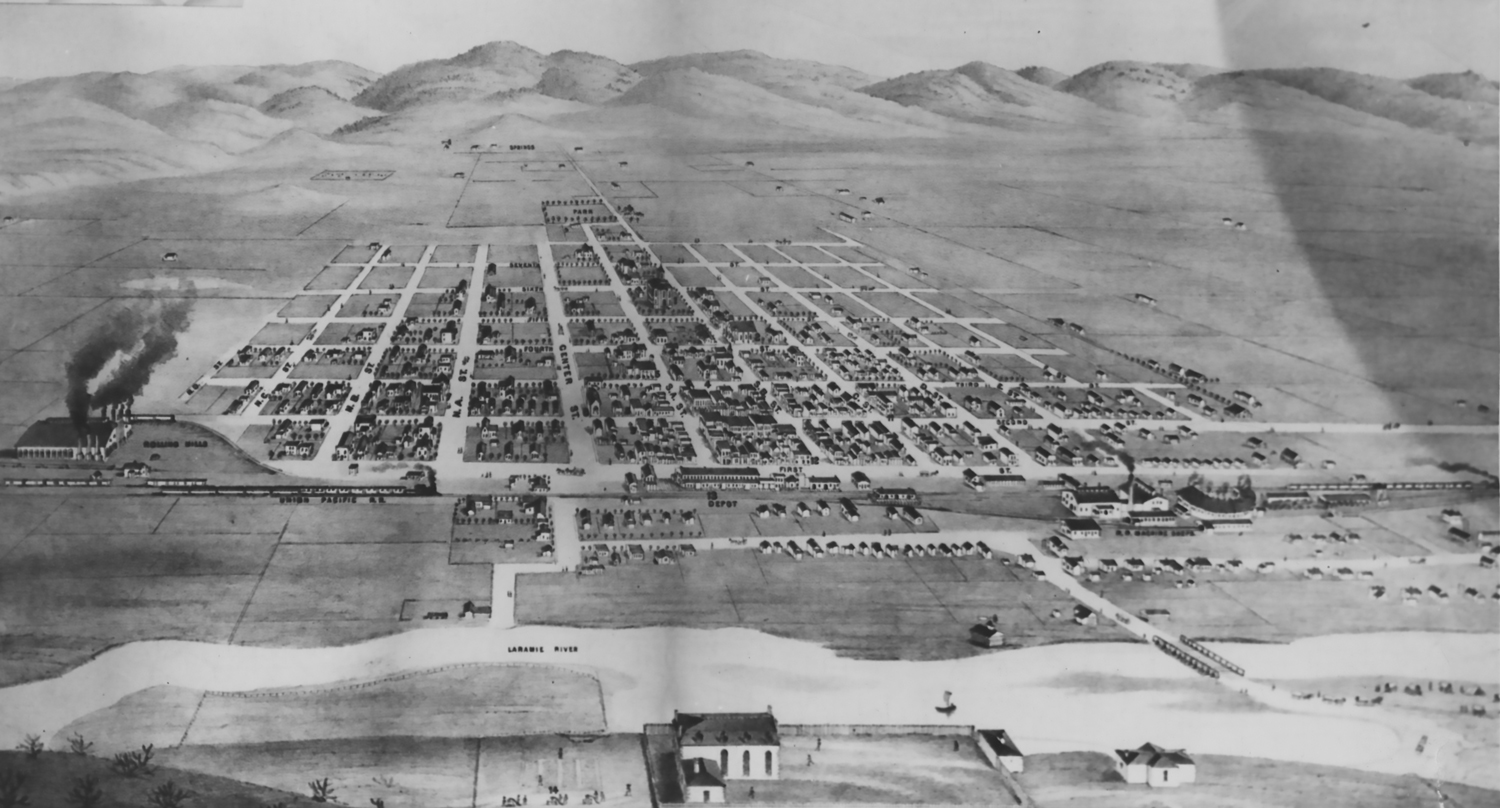
Laramie City grew very quickly, becoming a major town in southeastern Wyoming. The only town larger than Laramie at this time was Cheyenne. Above is a drawing of the town in 1875. Compare it to the 1870 drawing and you can see the growth that was rapidly occurring.
Learn more about the history of Fort Sanders and the building of the Transcontinental Railroad.